
Plans for GRSLE 2020 fieldwork have changed considerably since first roughed out in December 2019. At that time, the focus of our work was going to be in a remote area of the Washakie Wilderness continuing the investigation of methods to assess prehistoric migration corridor routes. As Spring 2020 assaulted us and a new variable was added to the field planning concerns (COVID-19), until recently it looked like would not be conducting archaeology fieldwork with a team this summer. Too many fuzzy variables and concerns. But after having spent considerable time sitting on and sometimes falling off the fence, although there are still huge doses of uncertainty to deal with, finally was able to cobble together a COVID-19 field protocol for being able to give near-maximum protection (maximum protection would be no team fieldwork) for all team members.
The plan is changing, and will no doubt continue to change as implemented, but at present addresses all concerns envisioned or communicated to me. Now have a smaller than originally thought crew and need to be within relatively easy access to medical facilities, so will be spending the first 14 days in a vehicle accessible field camp. The area selected is within hiking distance of areas of the Shoshone National Forest where we have been collecting data off and on since 2002. As an initial sampling design, the GRSLE project opted to use existing Showhone National Forest grazing allotments as suitable subareas for dispersing our sample plots across the Forest. Allotment boundaries tend to follow natural topographic breaks – ridgelines and streams – and are also management units that would have the greatest potential to be of use to Forest managers. We’ve wanted to project to be able to provide some data to aid in Forest heritage management. The focus of 2020 project will be on the one of these areas. After laying out background information on past GRSLE investigations in this single regional sample unit, specific goals for the 2020 field season and for use of the data collected are presented.
Sample Area Background
The sample area we’ll be focusing on in 2020 is one of the longest used areas of the Shoshone National Forest for domestic livestock grazing with a history of Euroamerican settler use of the mountain grasslands extending from the late 1800’s. Before that there were millennia of diverse uses of the area by Native American peoples. Our work here has focused on the pre-1880s uses but has added information on all aspects of this changing human interaction with the landscapes.
The sample unit itself covers about 14,010 ha and ranges in elevation from about 2400m to just over 4000 m. It is within the Absaroka Volcanic Supergroup geological deposits and is home to abundant wildlife and rich montane and alpine grasslands. Before being conceived of as the GRSLE project, our work began in this area in 2002 as a archaeological 10-day exploration with a group of Colorado State University (CSU) undergraduate students who had just completed their summer field school. From 2003-2006 the project combined CSU undergraduate and graduate students doing almost exclusively surface inventory and documentation. Ten MA thesis were eventually completed on aspects of this fieldwork (Bechberger 2010; Bohn 2007; Burnett 2005; Derr 2006; Kinneer 2007; Mueller 2007; Ollie 2008; Reiser 2010; Reitze 2004; Thompson 2012).
By spring 2006, several sites were selected for test excavations and perhaps subsequent excavation and by mid-summer of that year site testing was in full swing. And then the Little Venus Fire (LVF) started in June, and by mid-July we were forced from the field. In September, returned to examine some areas burned by the far and soon realized the archaeological record as we’d been recording on the vegetated ground surface was only the palest reflection of the near-surface archaeology (Todd 2015).
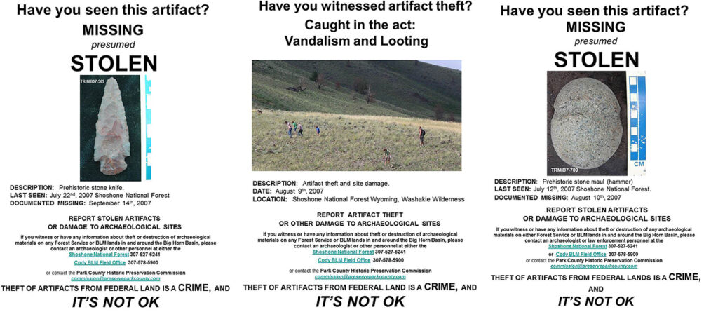
Work on the Little Venus and two other major fires in the Washakie Wilderness (Norton Point and Hardluck) has continued to reinforce the importance of systematic post-fire archaeological documentation. They also diverted the path of GRSLE research into unexpected directions (Todd 2015). One of these was a potential to research how changes in surface visibility (burned versus unburned) effects artifact surface visibility and assemblage content. Table 1 compares six sites recorded both before and after the Little Venus Fire (LVF).
The combined pre-and-post fire investigations of the allotment have resulted in the documentation of 56,756 artifacts (mostly debitage and chipped stone tools) and designation of 162 artifact clusters as archaeological sites. These numbers are based, in large part 1, on the systematic inventory and artifact-based documentation in only 845 ha (6.04% of the allotment). The artifact density of the Allotment is calculated as 67.2 artifacts/ha (i.e., 56,756 artifacts in 845 ha systematically inventoried). Of documented artifacts, 595 are projectile points, 258 are glass trade beads, and 145 are ceramic sherds. The overwhelming majority of documented items (N = 47,502) are small (mean maximum length = 12.5 mm) unmodified or lighted modified flakes. Of the projectile points, most are Late Prehistoric (N=272), with 165 Archaic (Early, Middle and Late combined), 13 Paleoindian, 103 fragments and not chronologically distinctive (see Reckin and Todd 2020 for review of our surface point chronology and Burnett 2005 for background on the project area)
One of the more striking differences that we’ve found in the allotment in the post-fire work is the relative abundance of sites with Euroamerican manufactured items such as glass bead, metal for projectile manufacture, percussion caps, cooking vessels (see examples in Todd 2019). In addition, the combination of exposure by burning off of surface duff and test excavations are beginning to produce nice assemblages of processed fauna, some of which has been used for the expanding the radiocarbon dating program for the Allotment (Bechberger 2010; Ollie 2008).
2020 Fieldwork
Rather than investigate previously unstudied areas (the proverbial blank spots on the map), which had been the goal of 2020 as envisioned pre-Pandemic, 2020 fieldwork will no focus on issues of long-term monitoring and on filling in the gaps, and adding to the data available within the already relatively well studied allotment. Specifically, the following activities/goals will be undertaken2:
- Revisit and do a full re-record of some of the sites that had been documented before the fire, and soon after (Table 1) to assess current condition;
- Conduct systematic, block inventory of at least 120 ha of previously un-surveyed area both within and outside the Washakie Wilderness for section 110 inventory;
- Visit previously documented sites with unique data potential to collect specialized data not gathered as part of the basic field coding protocol;
- Target obsidian item collection for source analysis to better understand regional and local patterns of source variation at the landscape scale;
- Conducted limited test excavations at additional sites to 1) provide better information for National Register of Historic Places (NRHP) eligibility evaluation and 2) to collect processed faunal remains for radiocarbon dating;
- Collect updated photographs of sites considered NRHP eligible;
- Attempt to relocate previously documented, but left in place artifacts;
- Collect additional core samples from old, ghost forest trees to help archive the dendroecological record in case of another major fire in the area.
- Harvest and deploy Hobo temperature recorders.
Specifically, each of these activities will collect data that can be part of trying to develop a more complete picture of the dynamics of prehistoric landuse through investigations of the archaeological record. Fundamental to such reconstructions based on regional inventory is an understanding how what is recorded on the contemporary ground surface reflects the nature of the archaeological – investigating how what we can see might reflect what’s there. This is the approach that is part of what GRSLE refers to as Landscape Taphonomy (Burger et al. 2008). The opportunity presented by the 2006 LVF to conduct the archaeological experiment of 1) collecting baseline data, 2) administering a treatment (in this case, we did not create the fire, just there to take advantage of the natural experiment), and 3) monitor change.
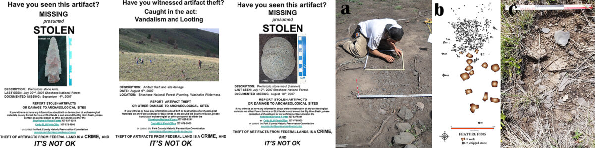
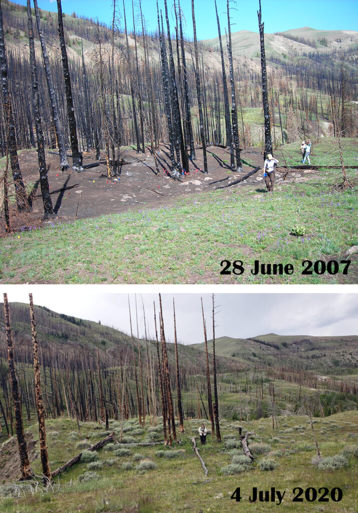
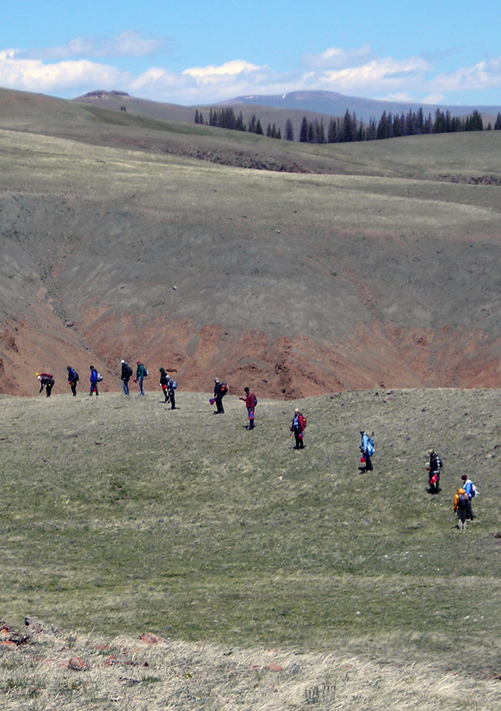
GOAL 1. Revisits. We initially recorded burned sites from 2007-2009, and now that 14 years have passed since the fire, can now look at how the processes of revegetation (Figure 1), and unfortunately probably artifact theft as well3 have impacted what can be recorded on a site’s surface. At least four, and hopefully more of the sites listed in Table 1 will be revisited, surveyed, flagged, mapped, and re-recorded. Special attention will be given to trying to relocate the diagnostic or likely to be collected artifacts such as the two shown in Figure 2. These data will provide a unique long-term, multiple documentation record of a surface archaeological record.
GOAL 2: Systematic Inventory. This allotment is one of the few areas on the Shoshone National Forest where the GRSLE project has met its target of 5% inventory of an allotment. In fact, at just over 6% inventoried, this is one of our best sampled areas in the Forest. However, there are still large portions of the Allotment that have had no work done. During 2020, we’ll aim to get systematic coverage and artifact-based documentation completed for at least another 120 ha of coverage, which would increase out total sampled area to almost 7%. Since many of our existing surveys have clustered in the areas that our probability model (Burnett et al. 2015) suggest should have the greatest likelihood of artifacts, in 2020 we’ll try to get more coverage in lower probability areas to provide a better dataset for additional evaluation and modification of the model.
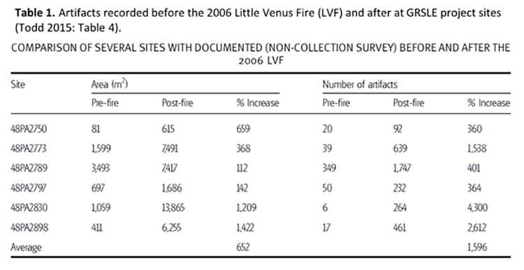
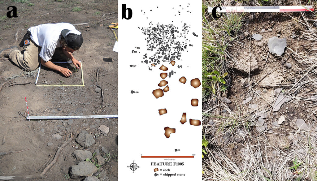
GOAL 3. Unique Data Capture Opportunities. While the first two goals emphasize broad, regional scale issues, the 2020 season also presents an opportunity for more detailed examination of activity level, specific event level investigations. Specifically, in 2009 as part of the LVF post-fire documentation, we recorded what seems to be a short term reduction area that used locally available contact metamorphic stone evidenced by a spatially discrete (N=405 artifacts in an area just over 1 m2), single source chipped stone reduction area (Figure 4a, b). This reduction area provides an exceptionally opportunity to Recording this area again in 2020 will also serve to provide additional information on specific attributes of chipped stone reduction and use strategies. This is a continuation of recent work with both materials from test excavations (Crable et al. 2018) and surface (Hofman et al. 2019) contexts. An ongoing research project by Dr. J.L. Hofman is comparing uses of a local (contact metamorphic, aka SLS) and non-local (obsidian) raw materials. In addition to these chipped stone specific results, the re-documentation of the reduction debris (Figure 4) will also add a fine-grained example of comparison of immediate post-fire (Figure 4a) in relation to conditions years after the burn (Figure 4c; photo take 4 July, 2020).
GOAL 4. Obsidian Sourcing. The allotment was part of early pre-LVF GRSLE project research (Bohn 2007) and additional samples have been collected and sourced from the area, the 2020 field season will emphasize using obsidian source locations to investigation potentials for temporal and landscape scale changes in use of this non-local material. Coupled with detailed investigation of obsidian reduction technology (Goal 3), additional sourcing study will add important information on the area’s prehistory.
GOAL 5. Test Excavations. As sites are re-visited and documented, one of the activities will be a detailed, systematic (Todd 2011) evaluation of National Register of Historic Places (NRHP) eligibility under criterion D. For several of these sites, a key question is the presence of buried archaeological deposits. Few of the sites in the eastern, non-Wilderness portions of the allotment have been tested and radiocarbon dates (Todd 2018) from the eastern portions are less abundant than those from the western, Wilderness section and sites with good indications of having buried faunal remains exhibiting evidence of prehistoric processing will be targeted for limited test excavation in 2020.
GOAL 6. Re-photograph. Some of the GRSLE project sites in the area were recorded nearly 20 years ago, and in need of updated photographs of current condition (see Figures 1 and 3). We will collect additional images of each site revisited.
GOAL 7. Re-located Previously Recorded Artifacts. Since GRSLE is a largely non-collection, in-field coding project, most items documented have been left in situ. In the early years of the project GPS accuracy of item locations was in the 5m range. For the last several years, the GNSS locational data has been collected with accuracies usually less than 50 cm. To both monitor possible artifact theft, to assess current condition, and to collect some newly added metric attributes, the 2020 project will include efforts to relocate as many of the nearly 500 diagnostic artifacts for which we have locational data.
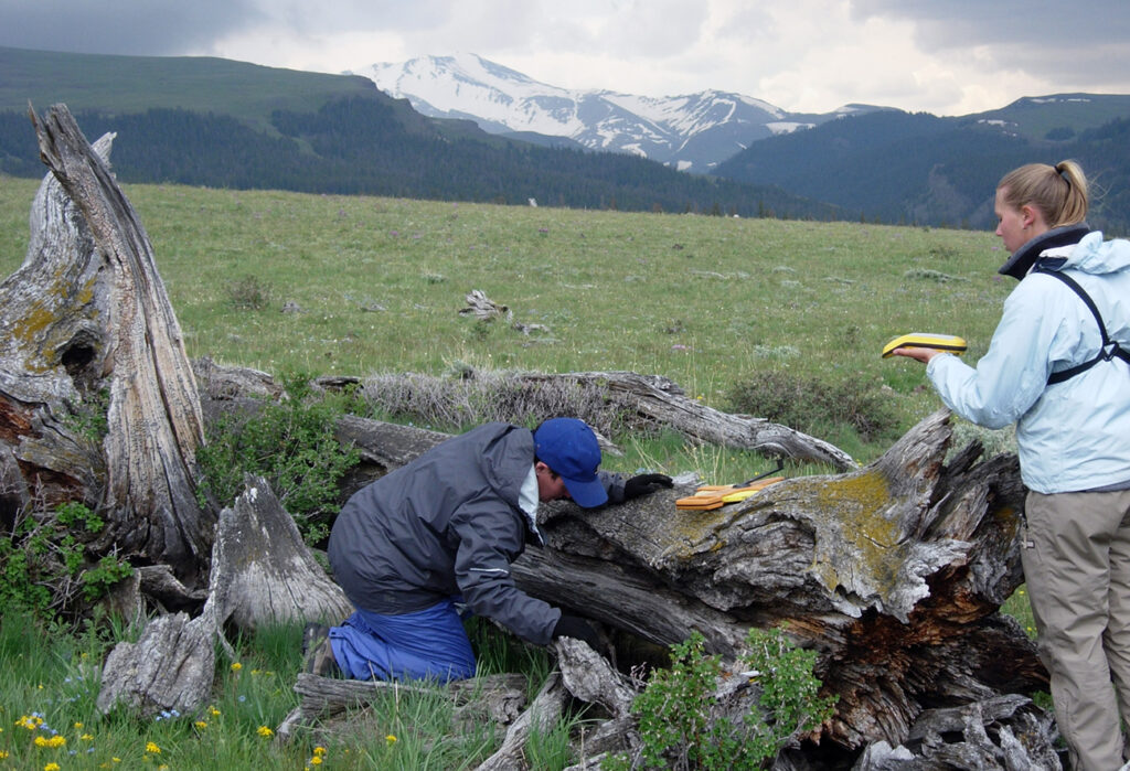
GOAL 8. Ghost Forest Documentation. Research in the allotment has included investigations using dendrochronology (Reiser 2010 and Thompson 2012) to research both cultural uses of the area, and to document past climates using both standing, and long-dead ghost forests (Figure 4). Locations and general descriptions of many of the old trees, many of which are 100’s of years old, have been recorded before the Little Venus Fire and a number of these important archives of past climatic data were destroyed in the fires. We have not, however done any systematic assessment of the remaining ghost forests and 2020 provides an opportunity to do so. When possible, sample of the remaining large trees (such as the one shown in Figure 4) will be collected and curated.
GOAL 9. Hobo harvest and Deployment. Following up on research that was undertaken by Derr as MA thesis research (2006), we have been set temperature recording devices in several locations in this area. There are several that were deployed previously that need to be collected and data downloaded. We will also be redeploying devices to continue to gather temperature data for this area, which has no near-by weather stations. This Goal is not included in Table 2, but can be done be one person and is a low risk COVID-19 activity.
All of the activities as well as field camp living will be undertaken under our COVID-19 mitigation protocol. Some of the fieldwork goals can be accomplished with minimal concern for possible viral transmission. For example, if a single crew member is out working to relocate artifacts using a GNSS receiver, other than initial equipment sanitation, no restrictions would be required – could work unencumbered with face covering, or worry about getting too close to others! A summary of the nine research goals (GOAL – Data Priority column) and the general level of COVID-19 restrictions that each would entail is provided in Table 2.
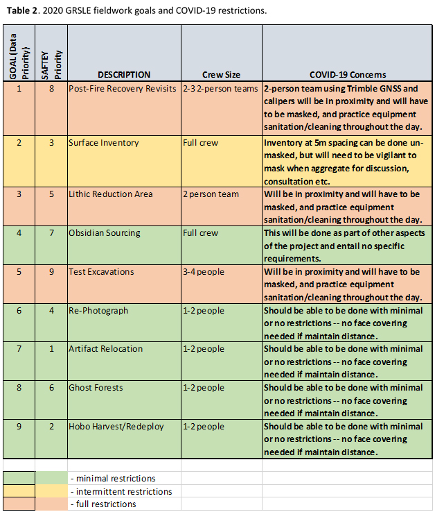
The Goals are listed in Table 2 in the order of highest immediate utility data — the things I’d most like to get done this season. If this were I normal year, I’d start witht the tasks that could take the most time and have the potential for being most unpredicatable. Mapping surface artifacts on large sites can take several days per site and if I want to get 4-5 sites re-recorded would plan on needing about eight days field time. Testing the sites should be fairly quick and could likely get done in 4-5 days. Both are data intensive and the activities would usually get up and running as soon as possible. This year, however, with the COVID-19 potential will do things a bit differently and plan to get the lowest risk activities started first — in the SAFETY Priority order (column 2). This way the more risky activities can be done in the tail of the diminishing potential innoculation curve. That’s to say, current data indicate that there is “a mean incubation period of 6.4 days (95% CI, 5.6 to 7.7 days), with a range of 2.1 to 11.1 day” (Lauer, et al. 2020). We’ll be most distanced when the probability is highest (first five days of the field session) and then, still following full protection protocol move to the higher contact time activities (site mapping and test excavation) for the last nine days of the session.
Schedule
As outlined in the COVID-19 protocol, the field session will be composed of two parts: 1) the first 14 days when the group will have no contact with outside persons, and comply with full isolation protocol until we’ve reached a stage at which we can operate as a COVID-19 free bubble group and 2) a second backcountry segment where other than a no contact with possible bubble-breachers4 (e.g., persons not part of the first 14 day group isolation period) rule, no restrictions will be required. There will be one option for off the mountain trip (not mandatory) for a resupply (from supplies in storage in Meeteetse, no grocery store visit), shower, and drop a crew member off at the airport trip on 31 August.
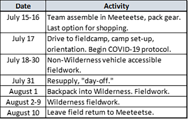
Specific dates, as currently planned for the summer project are given in Table 3. At this point, this is likely to be the final schedule, although unforeseen circumstances, such as someone in camp exhibiting COVID-19 symptoms during the first 14 days, may cause changes, this is the schedule that you should be able to plan around.
Footnotes:
- There are some artifact cluster discovered and recorded outside the boundaries of systematic block inventories.
- These goals are listed in a rough order of their priority. The total number of crew is still not known and depending on the total number that can come to the field, we may not be able to work on, or complete all these goals this season.
- It was not uncommon to visit archaeological sites after the fire and see a great many footprints of people who’d spent a long time apparently examining the exposed materials closely, and in some instances (Figure 2), we could document items that disappeared from sites after their initial documentation.
- You can all start right now working on submissions for the possible “no bubble-breacher” t-shirt design contest. You can enter you ideas in the comments.