
Data on individual clusters of artifacts and features that meet the Wyoming SHPO definition of a site will be included here based on the site designation. These data are part of the single, larger GRSLE cumulative dataset and are segregated here for easy of discussion. Overviews of some of the materia from several of these clusters are presented as in the beads or metal objects pages. A brief discussion of how these clusters are delineated is given here.
Cluster Delineation
The GRSLE project uses an artifact-based rather than site-based documentation and analytic approach with the individual artifact being the basic unit of observation. As noted, many of the fundamental perspectives that guide this work are inspired by Foley’s (1981) discussion off-site archaeology that emphasized the need to examine regional records from a perspective that incorporated awareness of both the human behavioral processes that can create artifact clusters and the multiplicity of other taphonomic processes on the formation, preservation, and exposure of artifacts. While this provides fertile ground for a variety of fundamental research questions and calls for non-standard methods, it also presents challenges for integrating our work with other archaeological information, which is nearly universally site-based. It’s difficult to make useful comparisons when different basic units of observation are employed. Similarly, the management needs, and protocols of the Forest Service are also site-based, so to make our inventory work of use, the basic data need to be partitioned into clusters that can be given individual descriptive designations – site numbers – and assemblage characterizations.
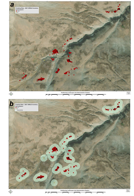
Figure 1. Partitioning continuous scatters into smaller artifact clusters: a) individually recorded artifacts in part of the Anderson Creek drainage – these are primary observations; 2) 15m buffers around each artifact to begin assessing those “within a 30-meter diameter area” as first step in converting archaeological units of observation into administrative clusters.
The protocol GRSLE has adopted to work between the archaeological and administrative site definitions is illustrated here. The Figure 1 shows the distribution of mapped chipped stone items in one of the alpine inventory block areas from the 2021 GRSLE project. In the field obvious clusters are given temporary cluster (“site”) designations and more dispersed items are given off-site (“IF”) designations. Visually the distribution of scatters and patches (Isaac 1981) of artifacts could be grouped into a variety of clusters. To operationalize the (N>15)+(dm<30) definition, each mapped artifact is given a 15m buffer, which allows groupings “within a 30 meter diameter area” to be identified.
Strict application of (N>15)+(dm<30) rule to this artifact distribution pattern would result in the designation of four artifact clusters (“sites”) and two off-site items (“IFs”) for this segment of landscape. However, this area is bisected by the drainage shown in, and some cluster separation seems appropriate. Figure 2 shows how the large central cluster in has been divided into three administrative clusters rather just one larger cluster.
In looking at Figures 1 and 2 the question might arise as to the rationality of having cluster GA21-31 be a single entity rather than making a judgement call and splitting it into three since there is just the slightest overlap (kissing clusters) that might better be described as three individual administrative units. Again, this is a case where on-the-ground observation has superseded strict (N>15)+(dm<30) rule application. Surface vegetation in the area labeled GA21-31 is dense and surface artifact visibility low over much of the area enclosed by the cluster polygon. In this case, the scatters and patches probably have much more to do with botany than archaeology, and it seems reasonable to maintain the three sub-clusters within a single administrative designation.
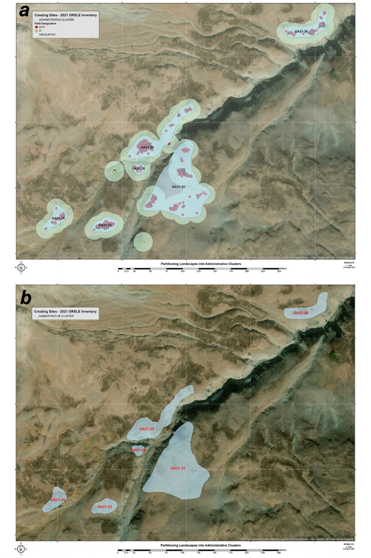
Figure 2. Step two in partitioning surface distributions into administrative clusters: a) recognition of significant geomorphological reasons to divide a strictly distance/artifact density defined cluster – three clusters are illustrated for the large 15m buffered cluster (GA21-25 – 48PA3661, GA21-31 – 48PA3665; GA21-35 – 48PA3666); and b) the map resulting when the archaeological observations are illustrated as the interpreted clusters. It is this last, interpretive summary that is usually presented as archaeological inventory results and for which SI numbers have been assigned by Wyoming SHPO.
References
Foley, R.A. 1981. Off-Site Archaeology: An Alternative for the Short-Sited. In Patterns of the Past: Essays in Honour of David L. Clarke, edited by I. Hodder, G. Isaac, and N. Hammond. Cambrige University Press, Cambridge.
Isaac, G. 1981. Stone Age Visting Cards: Approaches to the Study of Early Land Use Patterns. In Patterns of the Past: Studies in Honour of David Clarke, edited by I. Hodder, G. Isaac, and N. Hammond, pp. 131-155. Cambridge University Press, Cambridge.