
SCATTERED GLASS: OBSIDIAN ARTIFACT PROVENANCE PATTERNS IN NORTHWESTERN WYOMING
Click Thesis title to open fulltext pdf version of complete thesis
ABSTRACT OF THESIS
Home to several high quality sources of the volcanic glass material, obsidian artifacts are found throughout the archaeological record in northwestern Wyoming. Obsidian is a useful lithic raw material for evaluating prehistoric land use patterns because it can be matched with the geochemical signatures of source materials. As part of the Greybull River Sustainable Landscape Ecology (GRSLE) project, this research seeks to evaluate obsidian distribution patterns in the Upper Greybull watershed and the relationship to local and regional land use patterns. The study area is located within the volcanically formed Absaroka Mountain range where there is clear evidence of prehistoric land use from the Late Paleoindian period to recent times. Field and laboratory components were conducted to evaluate several research questions. During the field component, artifacts were recorded following pedestrian surveys and a sample of obsidian artifacts were collected for geochemical characterization. The laboratory component consisted of the geochemical and lithic analysis of the sampled artifacts.
Between 2002 and 2005, the GRSLE project recorded over 40,000 chipped stone artifacts from 166 sites and several isolated finds. Obsidian frequency is not uniform between the tributaries of the Upper Greybull and the material is most commonly found in the lower elevation ranges of the study area. Several varieties of raw material are available locally and regionally. Obsidian is a small portion of the total Greybull assemblage and artifacts are on average smaller than artifacts manufactured from other materials, indicating that obsidian is a highly curated raw material. The Late Prehistoric was the period of the most substantial obsidian use.
A sample of 127 obsidian artifacts was sent for geochemical characterization and revealed an overwhelming propensity toward Obsidian Cliff obsidian. The other obsidian sources responsible for multiple artifacts include Bear Gulch, Teton Pass, and Malad. Teton Pass is approximately the same distance from the GRSLE study area as Obsidian Cliff, but was identified less often. Most projectile points are Late Prehistoric in age and are constructed of Obsidian Cliff obsidian. Late Archaic projectile points in the sample were not constructed of Obsidian Cliff material. Expedient artifacts such as debitage and worked flakes were associated with the more common sources, while rare source artifacts are primarily projectile points or bifaces. There was not a significant difference in artifact size between the source types. Spatial analysis of two sites revealed that parsing out singular obsidian procurement events is highly dependent on site complexity.
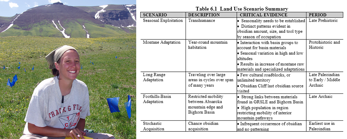
Three obsidian interaction zones are identified using several published regional sites and study areas. The GRSLE study area is similar to sites and areas to the north and east, but temporal variability needs to be better understood to evaluate possible shifts in the pattern. Five land use scenarios have been developed to consider possible land use patterns through time. These include seasonal exploitation, montane adaptation, long range adaptation, foothills-basin adaptation, and stochastic acquisition. Seasonal exploitation is the most probable scenario indicated by the available data. The Absaroka Range poses physiographic barriers to importing Obsidian Cliff material into the GRSLE study area. Research along the Boulder Basin Pack Trail will further define the relationship of the GRSLE study area to regional land use patterns.
Allison D. Bohn. Anthropology Department, Colorado State University. Fort Collins, CO 80523. Spring 2007