
SURFACE LITHIC SCATTERS IN THE CENTRAL ABSAROKAS OF WYOMING
Click Thesis title to open fulltext pdf version of complete thesis
ABSTRACT OF THESIS
This thesis provides baseline data on the variability of prehistoric lithic scatters documented across surfaces in the central Absaroka Range of northwestern Wyoming. Prehistoric hunter-gatherer behaviors and landscape attributes driving this variability are interpreted, and the dimensions controlling
archaeological variability in this montane setting are defined. Themes of behavioral continuity and change are common to researching human systems, and in the Absaroka Range this research is especially relevant for anthropologists and earth scientists studying Holocene change.
A total of 26,478 records of flaked stone data have been documented in situ within the montane watersheds of the Upper Greybull and Wood rivers, collectively referred to as the “Upper Greybull” for brevity. To describe the archaeological variability of these data, the periods of prehistoric human
occupation are first defined. The method of lithic cross-dating is used on the projectile point sample (n =224) to establish this sequence of prehistoric occupation. These artifacts were spread across 1050 km2, and variability in the abundances of projectile points is assumed to roughly reflect the intensity of occupation in the area. The results conform to other montane chronologies in the region, showing that the montane landscapes of the central Rocky Mountains were used maximally during the Late Archaic period (ca. 3000 –
1500 Radiocarbon Years Before Present [RCBP]), and that this land use was sustained but may have been slightly lower during the Late Prehistoric period (ca. 1500 – 250 RCBP). Land use earlier in the Holocene is evident, but it appears to have more than doubled during the Late Archaic.
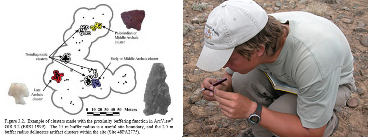
Artifact diversity associated with the diagnostic projectile points reflects some of the behavioral diversity of the hunter-gatherers that lived in this ecosystem. A GIS is used to create artifact clusters that are compared in terms of three variables: size (number of artifacts), toolstone variability, and artifact type
variability. While small clusters are by far the most populous, assemblages of all sizes occur in all elevations of the Upper Greybull. Large high elevation clusters were produced at toolstone procurement workshops, whereas large clusters in the low and middle montane elevations were made during residential camping activities.
To compare the variability in toolstone and artifact types in these assemblages, two indices are developed: the Toolstone Variability Index (TVI) and the Artifact Type Variability Index (AVI). These indices provide useful structure for the comparison of artifact assemblages not only in the Upper Greybull, but from any sample of assemblages with artifact type and toolstone data. Upper Greybull clusters exhibit a wide range of sizes and TVI and AVI values, but there is a tendency for clusters to have similar characteristics rather than each cluster being unique. This similarity reflects patterned settlement and subsistence behavior in response to topography and resource availability.
Variability in cluster toolstone proportions are largely conditioned by proximity to source areas. The nearest obsidian sources are on the western side of the Greater Yellowstone Ecosystem (GYE), and its presence in the Upper Greybull on the eastern side of the GYE indicates that hunter-gatherer mobility
patterns of the GYE included seasonally-patterned east-west intermontane travel in the course of a year. Most obsidian is associated with late Holocene time periods (post-3000 RCBP), indicating that patterned intermontane mobility regimes may not have been as common in the early Holocene as they were later.
Cluster artifact type proportions vary widely across the Upper Greybull. Both typical and atypical artifact type proportions are found throughout the sampled space. In the lower elevations (below ca. 2800 masl), projectile points are atypically abundant. These are the product of retooling activities conducted at
residential camps. Artifact type proportions are more variable in clusters not containing projectile points, and the majority of these clusters reflect task-specific non-residential activities.
Changing projectile point abundance and obsidian content indicates that the intensity of hunter-gatherer land use involving intermontane travel across the GYE increased after 3000 RCBP, and perhaps as early as 5000 RCBP, but reasons for this increased travel are unclear. Although regional mobility appears to have changed through time, artifact type proportions remained relatively unchanging in the Upper Greybull. This reflects low diachronic variability in local hunter-gatherer behaviors through time, amidst changes in regional mobility patterns. The intensity of land use changed through time, but similar
behaviors were employed when hunter-gatherers used the Upper Greybull landscape. This synthesis of surface lithic scatters in the Upper Greybull is proof that meaningful interpretations of prehistoric behavior can be drawn from an individual artifact-based approach to surface archaeological documentation.
Paul Burnett. Anthropology Department, Colorado State University. Fort Collins, CO 80523. Summer 2005